Our planet is full of incredible natural wonders, but some lakes are so strange they look like they belong on another planet. From blood-red waters and bubbling acidic pools to lakes that can seemingly turn animals into stone, these places are as fascinating as they are mysterious. Some are stunningly beautiful, while others are so dangerous that getting too close isn’t worth the risk.
Ready to discover some of the world’s most unusual lakes? Here are 10 of the weirdest and strangest lakes you’ll find across the globe.
1. Lake Natron
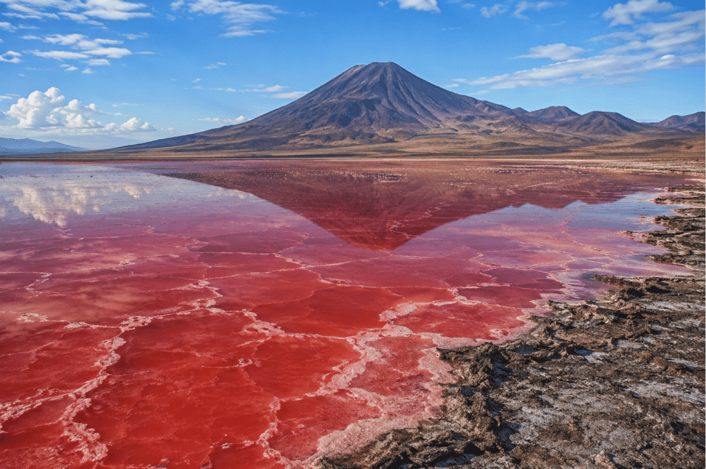
Lake Natron is one of the strangest and most fascinating lakes on Earth. With its blood-red waters, extreme alkalinity, and eerie reputation, it almost looks like something from another planet. While it’s deadly to many animals, it’s also one of the world’s most important breeding grounds for flamingos. It’s a place where life somehow thrives under conditions that seem almost impossible.
Located in northern Tanzania, near the Kenya border, Lake Natron stretches about 35 miles (57 km) long and 14 miles (22 km) wide. It sits at an elevation of around 1,970 feet (600 meters) above sea level and is a soda (alkaline) lake. Its main water sources are the Ewaso Ng’iro River and several mineral-rich hot springs. Unlike most lakes, Lake Natron has no outlet, so water can only leave through evaporation. As the water evaporates, minerals are left behind, making the lake even saltier and more alkaline.
Why Is Lake Natron Red?
The lake’s striking red color comes from tiny organisms that thrive in its salty, alkaline water. These include salt-loving algae and cyanobacteria (also known as blue-green bacteria). They produce red and orange pigments called carotenoids, especially when the water level drops and the salt concentration becomes even higher.
The lake’s color changes throughout the year. During the dry season, it often turns a deep crimson red. In some areas, it can appear orange or pink, while after heavy rains, it may fade to pale red or even gray.
Why Is It So Alkaline?
Lake Natron is one of the most alkaline lakes on Earth, with a pH ranging from about 9 to 10.5—almost as caustic as household ammonia. There are two main reasons for this. First, the region’s intense heat causes water to evaporate quickly, leaving minerals behind. Second, nearby volcanic activity constantly adds more alkaline minerals to the lake.
The biggest contributor is Ol Doinyo Lengai, an active volcano known as the “Mountain of God” by the Maasai people. It’s the only active volcano in the world that erupts natrocarbonatite lava—a rare type of lava rich in sodium and potassium carbonates. Unlike most lava, which erupts at temperatures above 1,000°C (1,832°F), this lava is much cooler, around 500–600°C (932–1,112°F). Fresh lava appears black before gradually weathering into white. Over time, these volcanic minerals help create Lake Natron’s unique chemistry.
How Hot Does It Get?
Lake Natron has a hot, semi-arid climate with two distinct seasons. During the dry season (June to October), water levels drop, salt concentrations increase, and the lake takes on its deepest shades of red. In the rainy season (November to May), water levels rise, diluting the lake and making its colors less intense.
Surface water temperatures can exceed 40°C (104°F), while air temperatures often reach 40–45°C (104–113°F). Combined with the lake’s extreme alkalinity, these harsh conditions make it difficult for most forms of life to survive.
As the dry season continues, the water evaporates even more, leaving behind thick salt crusts that can stretch for miles. The landscape becomes so surreal that it looks more like another planet than somewhere on Earth.
Can It Turn Animals Into Stone?
This is easily Lake Natron’s most famous myth—but no, it doesn’t literally turn animals into stone. Here’s what actually happens. Birds and bats occasionally die after colliding with the lake’s reflective surface or from natural causes. Their bodies become coated in alkaline salts and mineral deposits. Because the climate is so dry, decomposition slows down, leaving the animals remarkably well preserved. As a result, they can look as though they’ve been turned into stone.
This unusual phenomenon became famous through the dramatic photographs of wildlife photographer Nick Brandt. The animals aren’t petrified—they’re simply covered in mineral deposits.
Is It Dangerous to Humans?
For most people, briefly touching the water isn’t dangerous. However, prolonged contact can irritate your skin and eyes because of the lake’s high alkalinity. Drinking the water is unsafe, and walking across the salt crusts can also be risky since they may hide soft mud underneath. If you visit Lake Natron, it’s best to stay with experienced guides and admire this incredible place from a safe distance. Some places are better appreciated than explored.
Why Don’t Flamingos Die?
Surprisingly, what seems like a deadly environment for most animals is actually paradise for lesser flamingos.
Around 75% of the world’s lesser flamingos hatch here during many breeding seasons. They feed on the cyanobacteria growing in the lake, while their tough skin and specialized legs help them tolerate the highly alkaline water. The harsh conditions also keep many predators away, and the small salt islands provide safe places to build nests. During peak breeding seasons, millions of flamingos gather here, making Lake Natron the world’s most important breeding site for lesser flamingos.
Other Wildlife
Although the lake itself is extremely harsh, several species survive around its edges. Freshwater springs support tilapia fish, while insects and many migratory birds are commonly found nearby. Larger animals such as zebras, wildebeest, and giraffes also visit the area, but they stay close to freshwater sources rather than entering the lake itself.
Tourism
People visit Lake Natron to experience its breathtaking crimson waters, enormous flamingo colonies, vast salt flats, dramatic volcanic landscapes, and unforgettable sunrises and sunsets. It’s also a dream destination for photographers. The best time to visit is during the dry season, when the lake’s colors are at their most vibrant.
Why Lake Natron Matters
Lake Natron is much more than a beautiful natural wonder. It’s a remarkable example of how life can adapt to some of the harshest environments on Earth. Despite its extreme conditions, it supports unique microorganisms and serves as one of Africa’s most important breeding grounds for lesser flamingos. Its unusual chemistry, incredible wildlife, and ecological importance make Lake Natron one of the most extraordinary lakes on the planet—and a place well worth protecting.
2. Boiling Lake
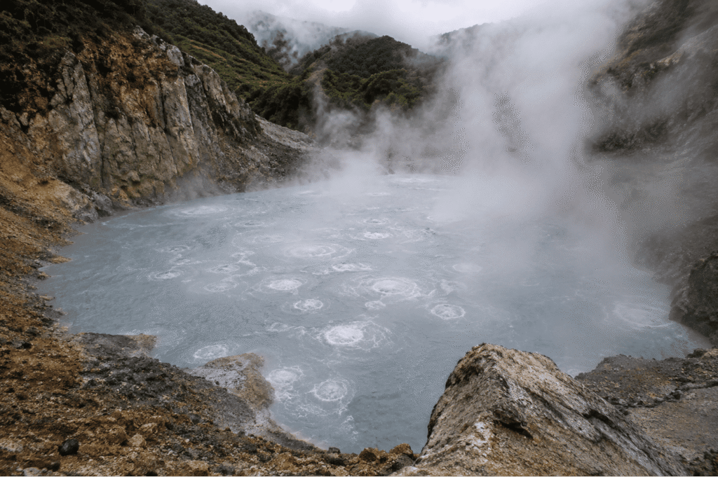
Boiling Lake is one of the world’s most extraordinary natural wonders. It’s the second-largest boiling lake on Earth, with New Zealand’s Frying Pan Lake taking the top spot. First documented by Europeans in 1870, this incredible lake isn’t filled with lava like many people imagine. Instead, it’s a flooded fumarole—a lake heated from below by volcanic gases and underground magma. The result is a lake that constantly bubbles, steams, and appears to boil, making it one of the planet’s most fascinating geothermal features.
Boiling Lake is located in Morne Trois Pitons National Park in Dominica, a UNESCO World Heritage Site. It sits about 2,625 feet (800 meters) above sea level and measures roughly 200–250 feet (60–75 meters) across. The lake’s water temperature ranges from about 180–198°F (82–92°C) near the edges, while scientists believe the center can reach the boiling point.
Why Is It Called “Boiling Lake”?
The name is pretty straightforward—the lake really does look like a giant pot of boiling water. Here’s what’s happening beneath the surface. Underground magma heats groundwater below the lake, while steam and volcanic gases rise through cracks in the Earth’s crust. This constant supply of heat keeps the water near its boiling point, creating endless bubbling, churning water, and rolling waves of steam. At times, the center of the lake disappears completely beneath thick clouds of steam.
Is the Water Really Boiling?
Yes—but not equally across the entire lake. The water around the edges is usually between 82–92°C (180–198°F), while the center is believed to reach about 212°F (100°C), depending on altitude and atmospheric pressure. The temperature isn’t constant, though. Rainfall, volcanic activity, and changing water levels can all affect it. After heavy rain, the lake has even been known to stop boiling temporarily before heating up again.
What Causes the Heat?
Boiling Lake sits above an active geothermal system. Its heat comes from a shallow magma chamber beneath the island, along with superheated groundwater, steam vents (fumaroles), and volcanic gases such as sulfur dioxide and carbon dioxide. Think of it as a giant natural kettle that’s continuously heated from below by Earth’s internal heat.
How Deep Is It?
No one knows for sure. Scientists have tried measuring the lake several times, but the task is extremely difficult. The near-boiling water, powerful underwater currents, and constantly shifting volcanic sediments make accurate measurements nearly impossible. Current estimates suggest the lake may be between 30 and 60 meters (100–200 feet) deep, but its true depth remains a mystery.
Why Is the Water Gray?
Unlike many crystal-blue lakes, Boiling Lake has a cloudy gray appearance. Its unusual color comes from fine volcanic sediments, dissolved minerals, sulfur compounds, and the constant mixing caused by the boiling water. Together, these materials scatter light differently, giving the lake its distinctive gray color.
Is It Dangerous?
Absolutely. Boiling Lake is one of the most dangerous lakes you could ever visit. The near-boiling water can cause severe burns within seconds, while sudden bursts of steam and toxic volcanic gases can also pose serious risks. Add slippery volcanic rocks and remote mountain terrain to the mix, and it’s easy to see why visitors should never attempt to enter the water. This is definitely a place to admire from a safe distance—not one to go swimming in.
How Do You Get There?
Getting to Boiling Lake isn’t easy. There are no roads leading directly to it, so the only way to reach the lake is by hiking.
The round-trip hike is about 8 miles (13 kilometers) and usually takes between 6 and 8 hours. The trail is considered moderate to strenuous and passes through dense rainforest, mountain ridges, river crossings, and the famous Valley of Desolation—a dramatic geothermal landscape filled with steaming vents, bubbling hot springs, and bright yellow sulfur deposits.
The hike is challenging, but for many visitors, the sight of the steaming lake at the end makes every step worthwhile.
3. Pitch Lake
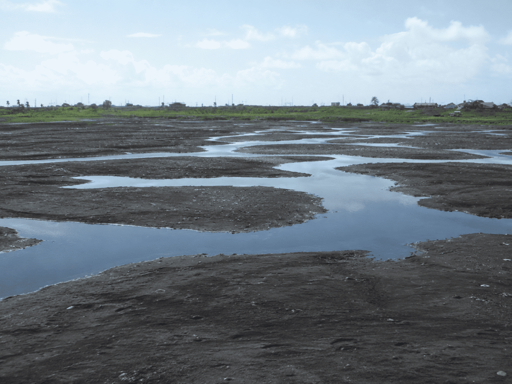
Pitch Lake is the largest natural deposit of asphalt (bitumen) on Earth. Covering around 100 acres (40 hectares), this incredible place looks like an endless stretch of black, cracked pavement. But unlike an ordinary lake filled with water, Pitch Lake is made almost entirely of semi-solid asphalt that slowly shifts and constantly renews itself.
Located in the town of La Brea in Trinidad and Tobago, the lake is estimated to be about 250 feet (75 meters) deep and contains roughly 10 million tonnes of natural asphalt. It formed when crude oil seeped up from deep underground and mixed with minerals, water, and natural gases over millions of years.
What Is Pitch Lake?
Despite its name, Pitch Lake isn’t really a lake of water. It’s a massive pool of natural asphalt—a sticky, black substance formed from crude oil.
Over millions of years, crude oil rose through cracks in the Earth’s crust. As it reached the surface, the lighter components evaporated, leaving behind heavy hydrocarbons that gradually thickened into asphalt. Rainwater and natural gases mixed with the bitumen, creating the unique surface we see today. The result is the world’s largest natural asphalt lake.
Why Doesn’t It Completely Harden?
Although the surface often looks solid, Pitch Lake is actually alive with slow movement. Fresh bitumen continuously rises from underground while natural gases bubble to the surface. The tropical heat keeps the asphalt soft, allowing it to flow—very slowly—like an incredibly thick liquid.
Walking across the lake can feel surprisingly strange. In some places, the surface feels firm, almost like walking on rubber, while other areas are much softer underfoot.
Can People Walk on It?
Yes! That’s one of the most surprising things about Pitch Lake. Visitors can actually walk across large parts of the lake, but only with an experienced guide. Most of the surface is stable enough to support people, although some sections are softer and can be a little sticky. Local guides know which areas are safe to cross.
Is It Dangerous?
Compared to many of the other unusual lakes on this list, Pitch Lake is relatively safe to visit—but it still comes with a few risks.
Some soft patches can cause your feet to sink slightly into the asphalt. The tropical sun can make exposed asphalt extremely hot, and thin crusts may hide small pools of water beneath the surface. In some areas, methane and other natural gases also escape from below. That’s why it’s always best to explore the lake with an experienced guide.
Why Does It Bubble?
The bubbling isn’t caused by boiling water—it’s caused by natural gases. Methane and other hydrocarbon gases slowly rise from deep underground, creating bubbles as they escape through the asphalt. These gases also help keep the lake in constant, slow motion.
Is the Asphalt Used for Roads?
Yes—and it has been for more than 150 years. Pitch Lake’s asphalt has been exported around the world because it’s naturally waterproof, extremely durable, and highly resistant to wear. Over the years, it has been used to pave roads and streets in major cities, including London, New York City, and Washington, D.C.
Ancient Discoveries
Pitch Lake is more than just a geological wonder—it’s also an incredible natural time capsule. Because the sticky asphalt preserves organic material so well, scientists have discovered ancient tree trunks, fossilized plants, insect remains, and even bones of prehistoric animals. Some of these remains have been preserved for thousands of years.
Local Legend
According to a legend told by the Indigenous Kalinago people (formerly known as the Caribs), the lake was created after villagers killed sacred hummingbirds, angering the gods. As punishment, the earth opened up and swallowed the entire village, leaving behind the enormous lake of pitch. While it’s only a legend, it remains an important part of the area’s cultural heritage.
Scientific Importance
Pitch Lake continues to fascinate scientists from around the world. It provides valuable insights into petroleum geology, natural hydrocarbon seepage, microorganisms that can survive in oil-rich environments, and even Earth’s climate history through the organic material preserved within the asphalt.
Perhaps the most surprising discovery is that microscopic life exists deep inside the asphalt, proving that organisms can survive in environments once thought to be too extreme for life.
4. Spotted Lake
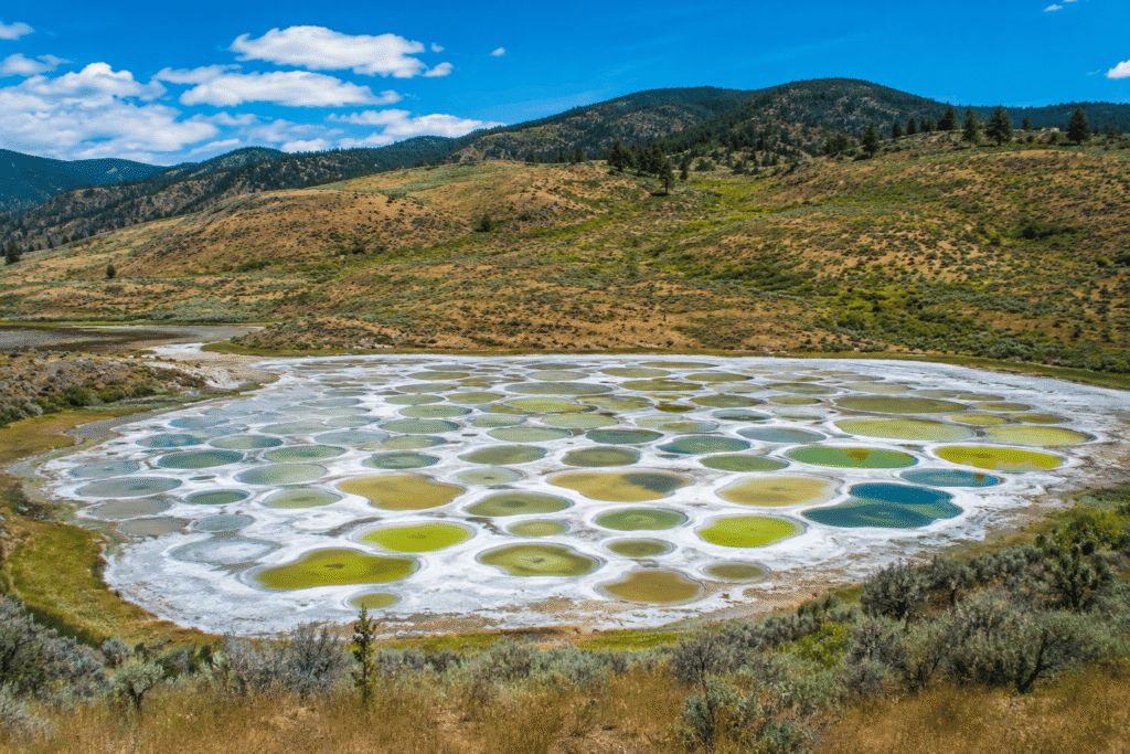
Spotted Lake is one of the world’s most unusual lakes. Every summer, as the water evaporates, it reveals hundreds of colorful mineral-rich pools that create a stunning pattern of blue, green, yellow, brown, and white “spots.” This incredible natural phenomenon has earned it the nickname “the polka-dot lake.”
Located near Osoyoos in British Columbia, Canada, Spotted Lake is an endorheic saline mineral lake, meaning it has no outlet and water leaves only through evaporation. It covers about 37 acres (15 hectares) and sits at an elevation of roughly 1,510 feet (460 meters) above sea level. It’s best known for the hundreds of colorful mineral pools that appear during the summer.
Why Is It Called Spotted Lake?
The name becomes obvious during the summer. As temperatures rise, the lake’s water evaporates rapidly in the region’s hot, dry climate. The dissolved minerals are left behind, forming natural ridges that separate small pools of water. Each pool becomes a distinct circular “spot.”
Depending on the minerals inside, every spot can have a different color, creating a breathtaking mosaic that’s easily visible from nearby hills and roads. The best time to see this incredible display is between July and September, when the spots are most clearly defined.
Why Are the Spots Different Colors?
The lake’s vibrant colors come from its exceptionally high concentration of dissolved minerals. These include magnesium sulfate (Epsom salt), calcium, sodium sulfate, magnesium, silver, titanium, and small amounts of other trace minerals. Different combinations of these minerals reflect light in different ways, producing shades of blue, green, yellow, turquoise, brown, and white.
The colors aren’t exactly the same every year. Rainfall and evaporation affect the mineral concentrations, so the appearance of the lake changes slightly from one summer to the next.
How Many Spots Are There?
There’s no fixed number. During especially dry summers, more than 300 separate mineral pools have been identified. In wetter years, fewer spots appear because more of the lake remains covered with water.
Why Doesn’t the Lake Dry Up Completely?
Even though much of the water evaporates each summer, the lake never disappears entirely. Some water remains trapped in natural mineral basins, while underground groundwater continues to feed the lake. Different minerals also crystallize at different rates, helping preserve the distinct pools that make Spotted Lake so unique.
Is It Dangerous?
Not really. Unlike highly alkaline lakes or boiling geothermal lakes, Spotted Lake isn’t considered dangerous. However, the mineral-rich mud can be slippery, and the delicate mineral crust is easily damaged. To protect this rare natural wonder, visitors aren’t allowed to enter the lake.
Can You Swim in It?
No. Swimming and public access to the lake itself are prohibited. Instead, visitors enjoy the view from designated viewpoints overlooking the lake. These restrictions help preserve both its fragile ecosystem and its cultural significance.
Why Is It Sacred?
Spotted Lake holds deep cultural and spiritual importance for the Syilx (Okanagan) Nation. For centuries, Indigenous communities have considered the lake a place of healing. According to traditional beliefs, each mineral pool possesses its own unique healing properties, and the lake has long been used for ceremonial and medicinal purposes.
Because of its cultural significance, visitors are asked to respect the site by admiring it from a distance rather than entering it.
A Lake Once Used During War
Spotted Lake even played a small role during World War I. The lake’s minerals—particularly magnesium sulfate—were reportedly harvested for use in manufacturing ammunition and explosives. For a short time, this remarkable natural wonder became an important source of industrial materials before returning to being one of Canada’s most fascinating landscapes.
5. Lake Hillier
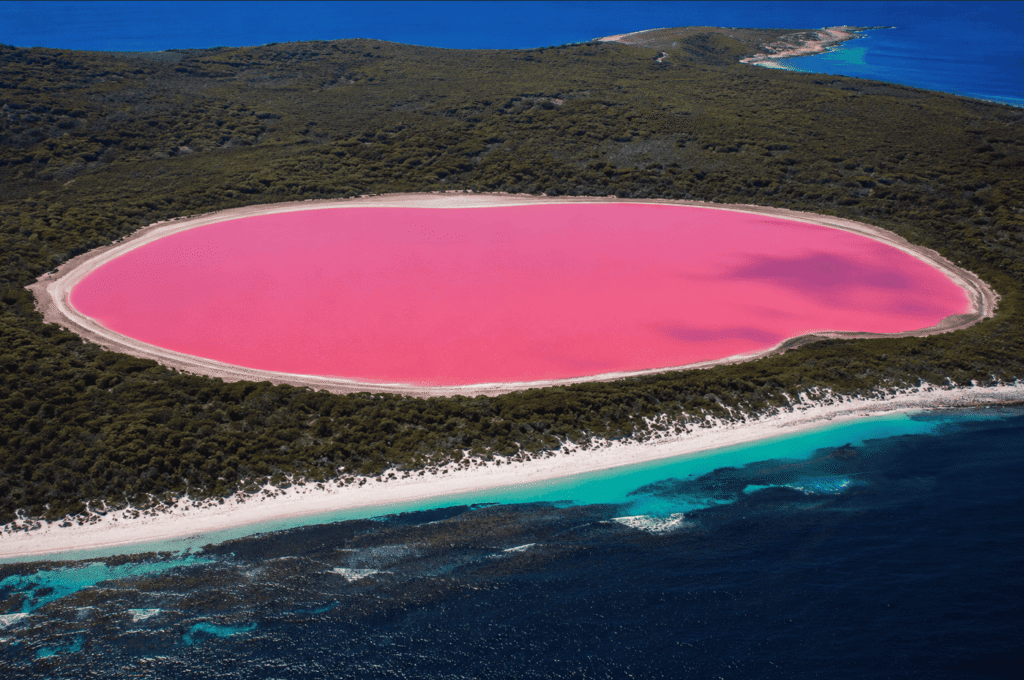
Lake Hillier is one of the world’s most famous pink lakes. Its vivid bubblegum-pink water creates a breathtaking contrast against the deep blue waters of the Southern Ocean and the lush green forests of Middle Island. Unlike many pink lakes that change color with the seasons, Lake Hillier is famous for staying bright pink all year round.
The lake was first recorded by British explorer Matthew Flinders in 1802. While climbing the highest point on Middle Island, he spotted the striking pink lake and described it in his journal.
Located on Middle Island, off the southern coast of Western Australia, Lake Hillier is a saline (salt) lake measuring about 1,970 feet (600 meters) long and 820 feet (250 meters) wide. It covers approximately 37 acres (15 hectares) and reaches a maximum depth of around 13–16 feet (4–5 meters). Its permanent bright pink water has made it one of Australia’s most extraordinary natural attractions.
Why Is Lake Hillier Pink?
Scientists believe the lake’s famous pink color comes from a combination of several natural factors. One of the main contributors is Dunaliella salina, a salt-loving microalga that produces orange-red pigments called carotenoids. The lake is also home to halophilic (salt-loving) bacteria and archaea, which produce reddish pigments of their own.
Combined with the lake’s extremely high salt concentration, these microorganisms create the vibrant pink color that makes Lake Hillier so unique.
Does the Water Stay Pink in a Bottle?
Yes—it does! One of Lake Hillier’s most remarkable features is that its water usually remains pink even after it’s collected in a bottle or container. Many other pink lakes lose their color once the water is removed, but Lake Hillier’s water generally keeps its rosy hue because the pigmented microorganisms remain suspended in it.
How Salty Is It?
Lake Hillier is extremely salty, with salinity levels comparable to—or even higher than—those of seawater. This harsh environment allows very few organisms to survive, but it’s perfect for the salt-loving microbes responsible for the lake’s famous color. The high salt concentration also helps maintain the lake’s unique ecosystem.
Can You Visit?
Yes—but getting there isn’t easy. Since the lake is located on protected Middle Island, independent access is limited and usually requires special authorization. Most visitors experience the lake through scenic airplane flights, helicopter tours, or licensed boat tours, which offer spectacular views of the vibrant pink water from above.
Is It Safe to Swim?
Surprisingly, yes. Unlike highly alkaline lakes such as Lake Natron, Lake Hillier isn’t known to be chemically dangerous to healthy people. However, swimming is rarely allowed because the lake and its surrounding environment are protected.
Most visitors admire the lake from the air or on guided tours rather than entering the water.
Why Is the Lake Separated from the Ocean?
One of the most fascinating things about Lake Hillier is that it’s located just a few meters from the Southern Ocean, yet the two bodies of water rarely mix.
A narrow strip of sand dunes and dense vegetation acts as a natural barrier between the lake and the sea. While rainfall and underground seepage help regulate the lake’s water levels, very little ocean water enters the lake directly. This natural separation helps preserve the lake’s unusual chemistry and is one of the reasons it has remained brilliantly pink for so long.
6. The Morning Glory Pool
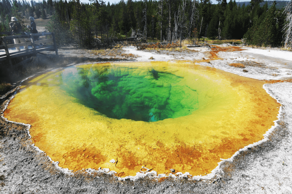
Morning Glory Pool is one of the most beautiful and famous hot springs in the world. Its brilliant blue center, surrounded by rings of green, yellow, orange, and red, looks remarkably like the petals of a morning glory flower—giving the pool its name. This stunning geothermal spring is heated by Yellowstone’s volcanic system beneath the Earth’s surface and is one of the park’s most photographed natural wonders.
Located in Yellowstone National Park in the United States, Morning Glory Pool measures about 23–30 feet (7–9 meters) across and is approximately 23 feet (7 meters) deep. Its water temperature typically ranges between 158–176°F (70–80°C). The pool is best known for its crystal-clear blue center and striking rainbow-colored edges.
Why Is It Called Morning Glory Pool?
The pool was named because its appearance reminded early visitors of a morning glory flower. The name was reportedly suggested in the late 19th century by Mrs. E. N. McGowan, who thought the spring looked just like the flower when viewed from above. More than a century later, the comparison still fits perfectly.
Why Is It So Colorful?
The pool’s spectacular colors are created by two natural factors. The deep blue center comes from exceptionally clear water. As sunlight passes through it, blue wavelengths are scattered back to our eyes while other colors are absorbed, giving the center its vivid sapphire-blue appearance.
Around the edges, the water is slightly cooler, allowing heat-loving microorganisms—such as bacteria and archaea—to thrive. Different temperatures support different species, creating colorful rings of green, yellow, orange, and red. These living microbial mats act like natural pigments, producing the pool’s famous rainbow effect.
Why Has Its Color Changed Over Time?
Morning Glory Pool wasn’t always as colorful as it is today. Originally, much of the spring was a deep, uniform blue because the water was hotter. Over the years, however, many visitors tossed coins, rocks, trash, and other objects into the pool. These items partially clogged the underground vents that circulate hot water.
As the flow slowed, parts of the spring cooled slightly. Those cooler temperatures allowed colorful microorganisms to spread farther toward the center, creating the orange, yellow, and green rings that are much more prominent today.
Ironically, some of the rainbow colors that make the pool so famous today are the result of human impact rather than completely natural conditions.
How Does the Hot Spring Form?
Like many of Yellowstone’s geothermal features, Morning Glory Pool is powered by an underground heating system. Rain and snowmelt seep deep into the ground, where they’re heated by the enormous magma chamber beneath Yellowstone. The hot water then rises back to the surface through cracks and fractures in the Earth’s crust, creating the steaming hot spring we see today.
Is It Dangerous?
Yes. Although it’s beautiful, Morning Glory Pool is extremely dangerous. The water is hot enough to cause severe burns in seconds. The ground around geothermal areas can also be thin and fragile, with scalding water hidden just beneath the surface. In some parts of Yellowstone, naturally occurring geothermal gases may also be present.
For your safety—and to protect the fragile environment—always stay on the designated boardwalks and marked trails.
Can You Swim in It?
Absolutely not. Swimming is strictly prohibited because the water is dangerously hot and can cause life-threatening burns. Entering the pool would also damage the delicate microbial ecosystem that gives it its incredible colors.
Besides, it’s illegal to enter any of Yellowstone’s protected hot springs. This is definitely a place to admire with your eyes—not your swimsuit.
7. Lake Karachay
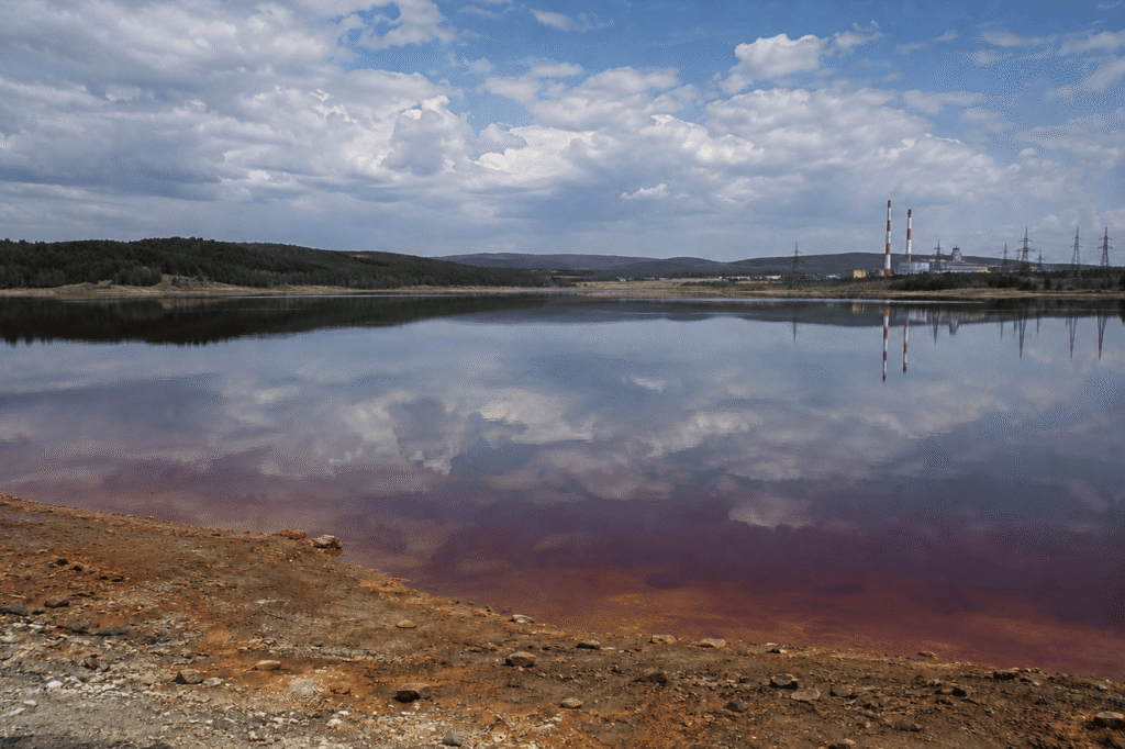
Lake Karachay is one of the most radioactive places ever created by human activity. Unlike naturally dangerous lakes filled with boiling water or toxic chemicals, this lake became deadly because it was used as a dumping site for high-level radioactive waste during the Soviet era.
Today, the original lake has been covered with rock and concrete to help contain the contamination. Although the risk of radioactive dust spreading has been greatly reduced, the area remains heavily contaminated and is completely closed to the public.
Where Is Lake Karachay?
Lake Karachay is located in the southern Ural Mountains of Russia, in Chelyabinsk Oblast, near the closed city of Ozersk. It lies within a highly restricted nuclear-industrial zone and is not open to tourists because of ongoing radiation hazards.
Originally, it was a small freshwater lake. Today, it’s best known as the former disposal site for radioactive waste from the nearby Mayak Production Association, one of the Soviet Union’s major nuclear facilities.
Why Is It So Radioactive?
The contamination began in 1951, when the nearby Mayak nuclear facility started using the lake as a dumping site for liquid radioactive waste produced during nuclear weapons development.
Over the following years, enormous amounts of radioactive material accumulated in the lake, including isotopes such as cesium-137, strontium-90, plutonium, and many other radioactive fission products. As a result, Lake Karachay became one of the most contaminated places on Earth.
How Dangerous Was It?
At its peak during the 1960s, radiation levels around parts of the lake were extraordinarily high.
Scientists estimated that spending about one hour near the most contaminated sections of the shoreline could expose a person to a potentially fatal dose of radiation, although the exact risk depended on the location and conditions at the time. Few places on Earth have ever reached such extreme levels of radioactive contamination.
The 1967 Disaster
One of the most serious accidents occurred in 1967 after a prolonged drought caused parts of the lake to dry up.
Strong winds picked up radioactive dust from the exposed lakebed and carried it across the surrounding region. Thousands of people were exposed to radioactive contamination, and large areas of land were affected. The incident demonstrated just how dangerous it was to store radioactive waste in an open lake.
Why Was the Lake Filled In?
To prevent radioactive sediments from becoming airborne again, Russian authorities gradually covered the lake with large concrete blocks, rocks, and layers of soil.
The project was completed in 2015, effectively sealing the lake beneath an engineered barrier. While the radioactive waste is still there, the cover significantly reduces the risk of contaminated dust being spread by the wind.
Can You Visit?
No. Lake Karachay lies inside a highly restricted nuclear zone, and public access is prohibited. The site remains off-limits because of radiation hazards, environmental contamination, and security restrictions.
Is the Lake Still There?
Technically, yes—but it’s hidden beneath its protective cover.
The original lake was buried rather than removed, and the radioactive waste remains sealed underneath. The engineered barrier is designed to isolate the contamination and prevent it from spreading into the surrounding environment.
Although cleanup efforts have greatly reduced the immediate risks, contamination has affected nearby soil, groundwater, rivers, and local ecosystems. The area continues to be closely monitored, making Lake Karachay a lasting reminder of the environmental consequences of improper nuclear waste disposal.
8. Kawah Ijen Acid Lake
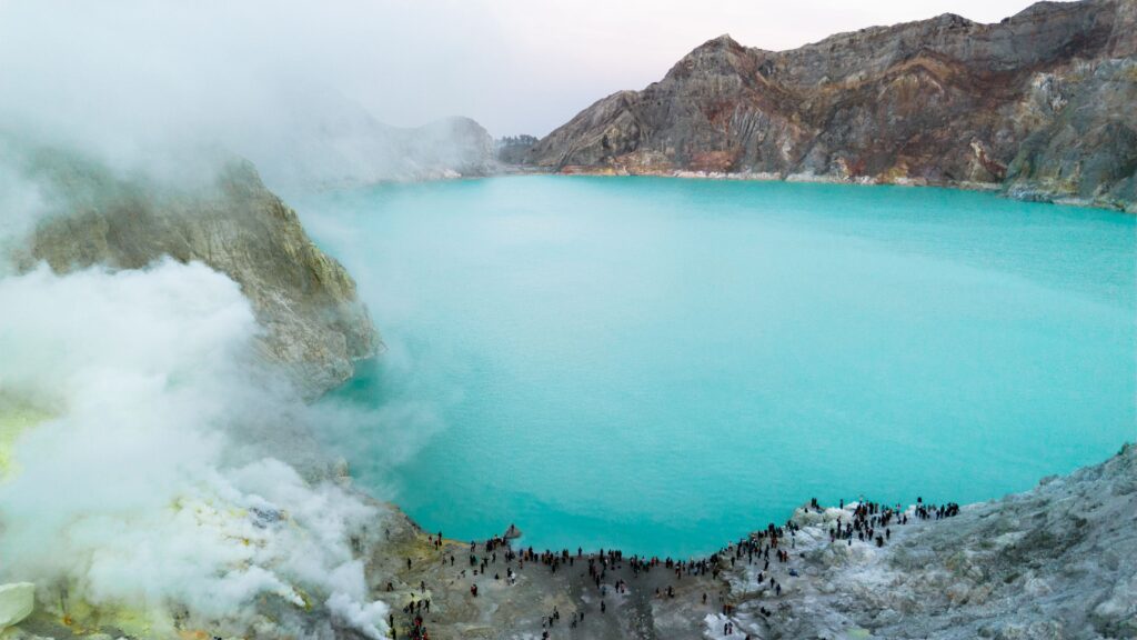
The acid lake of Kawah Ijen is the world’s largest highly acidic volcanic crater lake. Famous for its brilliant turquoise water, spectacular blue fire, and traditional sulfur mining, it’s one of Indonesia’s most extraordinary natural wonders. As beautiful as it looks, however, the lake is incredibly dangerous. Its water is so acidic that even brief contact can cause serious chemical burns.
Located inside the Kawah Ijen volcanic complex on the island of Java, Indonesia, the lake measures about 3,150 feet (960 meters) across and covers roughly 101 acres (41 hectares). It reaches a maximum depth of around 660 feet (200 meters) and sits at an elevation of approximately 7,047 feet (2,148 meters) above sea level. With a pH of just 0.2 to 0.5, it’s one of the most acidic lakes on Earth.
Why Is the Lake Turquoise?
The lake’s brilliant turquoise color is completely natural. Its unique appearance comes from a combination of dissolved sulfur compounds, sulfuric and hydrochloric acids, and tiny suspended mineral particles that scatter sunlight. Although the water itself is clear, its unusual chemistry reflects light in a way that creates the lake’s striking blue-green color.
Why Is It So Acidic?
Kawah Ijen’s extreme acidity is caused by constant volcanic activity beneath the surface.
Volcanic gases such as sulfur dioxide (SO₂), hydrogen sulfide (H₂S), and hydrogen chloride (HCl) rise from magma deep below the crater. When these gases dissolve into the lake, they react with the water to form powerful acids, mainly sulfuric acid and hydrochloric acid.
With a pH between 0.2 and 0.5, the lake can be even more acidic than battery acid, making it one of the harshest natural environments on the planet.
What Is the Blue Fire?
One of Kawah Ijen’s most famous attractions is its mysterious blue fire. Despite what many people think, it isn’t blue lava.
Instead, sulfur-rich volcanic gases escape through cracks in the ground. As these gases mix with oxygen, they ignite and burn with brilliant electric-blue flames. Burning sulfur can reach temperatures above 1,112°F (600°C).
The blue flames are only visible at night or before sunrise. During the day, they’re largely hidden by sunlight.
Is the Lake Dangerous?
Absolutely.
The lake’s highly acidic water is capable of causing severe chemical burns, and the surrounding crater presents several other hazards. Toxic volcanic gases, sudden gas releases, steep crater walls, loose rocks, and ongoing volcanic activity all make this a potentially dangerous place to visit.
Visitors should never enter the water, and gas masks are often recommended when volcanic gases become concentrated. And yes—swimming here is completely out of the question.
Sulfur Mining
Kawah Ijen is also famous for its traditional sulfur mining, one of the toughest jobs in the world.
Miners climb into the crater, break solid sulfur deposits by hand, and carry heavy baskets weighing 130–200 pounds (60–90 kilograms) up the steep mountain trails. The sulfur is later used in fertilizers, chemical manufacturing, sugar refining, and various industrial processes.
Despite modern technology, much of the mining is still done manually, making it physically exhausting work while exposing miners to heat and sulfur fumes every day.
9. Jellyfish Lake
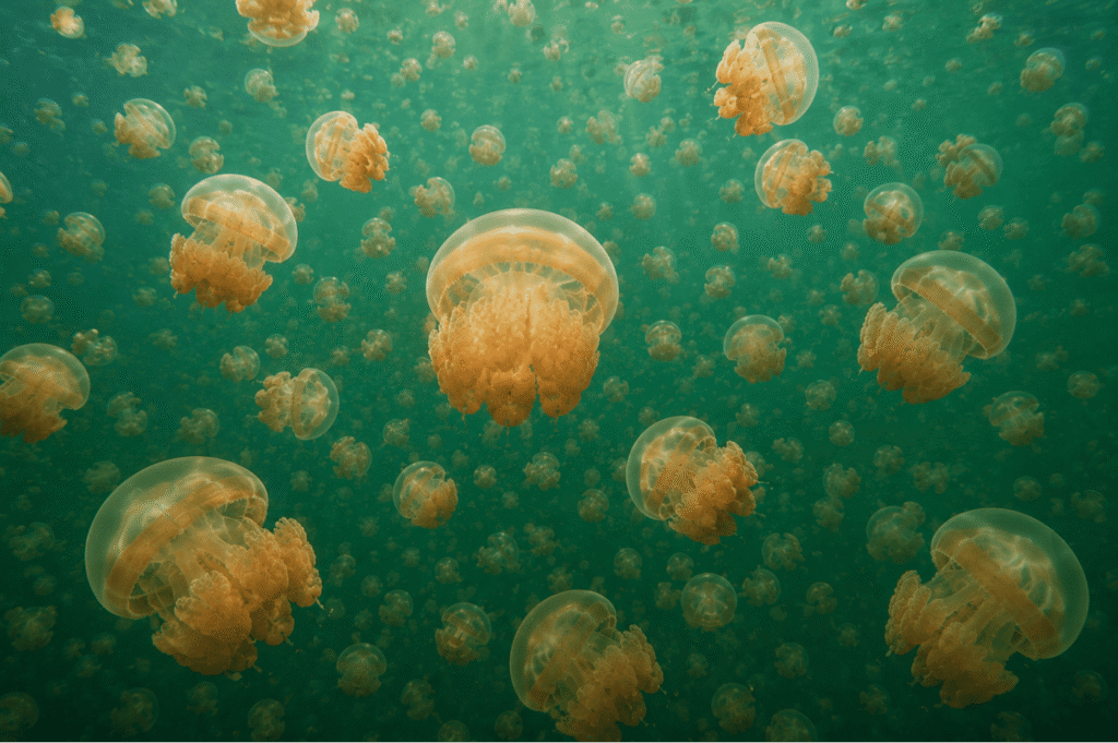
Jellyfish Lake is one of the most extraordinary lakes on Earth. It’s home to millions of jellyfish that have evolved to become virtually harmless to humans, making it one of the few places in the world where you can safely swim among huge swarms of jellyfish.
Located on the small island of Eil Malk in the island nation of Palau, the lake has been isolated from the surrounding ocean for thousands of years, turning it into a remarkable natural laboratory for evolution. It covers about 14 acres (5.7 hectares), reaches a maximum depth of around 160 feet (50 meters), and is believed to be roughly 12,000 years old.
How Did the Lake Form?
Jellyfish Lake was created around 12,000 years ago, near the end of the last Ice Age.
As sea levels rose, a section of the ocean became trapped inside a limestone basin. Over time, the basin became almost completely isolated from the surrounding sea. Today, tiny cracks and tunnels in the limestone still allow a small amount of seawater to pass through, but not enough to reconnect the lake with the open ocean.
This long isolation created an ecosystem found nowhere else on Earth.
Why Are the Jellyfish Almost Stingless?
The lake is home to two main species: the golden jellyfish and the moon jelly. For thousands of years, these jellyfish lived without most of the predators found in the open ocean. Since they no longer needed powerful defenses, their stinging cells gradually became much weaker through evolution.
As a result, their stings are generally too mild to affect most people. Those with very sensitive skin may experience slight irritation, but serious reactions are extremely rare.
Why Do the Jellyfish Swim Across the Lake Every Day?
One of the lake’s most fascinating sights is the jellyfish’s daily migration. Every morning, they swim toward the eastern side of the lake. As the Sun moves across the sky, they slowly make their way west.
They aren’t following the Sun by accident. Tiny microscopic algae living inside their bodies rely on sunlight to perform photosynthesis. The jellyfish provide the algae with nutrients and a safe place to live, while the algae produce food that helps nourish the jellyfish. It’s a perfect example of nature working together.
What Is a Meromictic Lake?
Jellyfish Lake is what’s known as a meromictic lake, meaning its water is permanently divided into layers that rarely mix. The upper layer, extending to about 15 meters (50 feet), contains oxygen and supports nearly all of the lake’s life, including the jellyfish.
Below roughly 15–20 meters, the water contains little to no oxygen and is rich in hydrogen sulfide, a toxic gas that is deadly to most forms of life. For this reason, visitors are not allowed to dive into the deeper layers.
Can You Swim in the Lake?
Yes—but only by snorkeling. Scuba diving isn’t allowed because the air bubbles released by divers can become trapped beneath the jellyfish, potentially damaging their delicate tissues. Diving could also disturb the lake’s deeper, toxic layers.
Instead, visitors gently float on the surface while snorkeling, allowing the jellyfish to drift peacefully around them.
Is It Dangerous?
Not really. For most visitors, Jellyfish Lake is a very safe place to explore. The jellyfish are virtually harmless, although people with sensitive skin might notice a mild sting. Other minor hazards include strong tropical sunlight, slippery rocks along the shoreline, and the toxic deep water if someone were to descend below the safe snorkeling zone.
As long as visitors follow park regulations, it’s an unforgettable and safe experience.
Conservation Challenges
Like many fragile ecosystems, Jellyfish Lake has faced environmental challenges. In 1998, a powerful El Niño event dramatically warmed the lake, causing many of the microscopic algae to die. Without their algae, the jellyfish population collapsed.
Although the lake later recovered, another major population decline occurred around 2016. Today, jellyfish numbers continue to rise and fall naturally, and scientists closely monitor the lake to help protect this unique ecosystem for future generations.
10. Abraham Lake
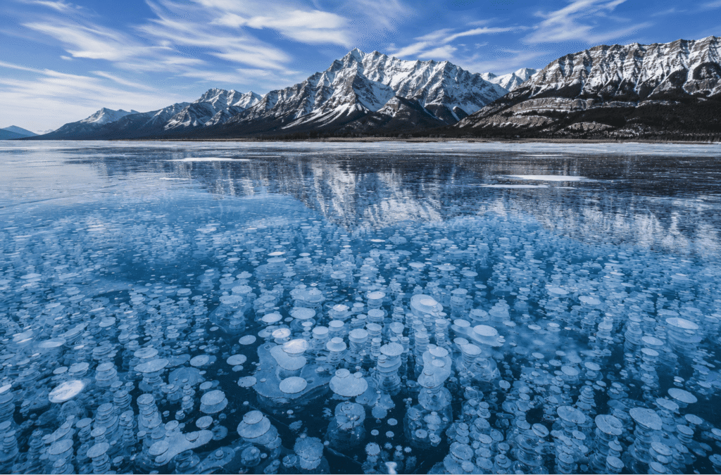
Abraham Lake is one of Canada’s most spectacular lakes, famous for the incredible frozen methane bubbles trapped beneath its crystal-clear ice every winter. These white, stacked bubbles create one of the world’s most photographed natural phenomena, making the lake a favorite destination for photographers and nature lovers alike.
Despite its wild, natural appearance, Abraham Lake isn’t actually a natural lake. It’s a human-made reservoir surrounded by the breathtaking peaks of the Canadian Rockies.
Located in Alberta, Canada, the reservoir was created in 1972 after the construction of the Bighorn Dam. It stretches for about 20 miles (32 kilometers), covers roughly 20 square miles (53 square kilometers), and is fed primarily by the North Saskatchewan River.
How Was Abraham Lake Created?
Abraham Lake was formed in 1972 when the Bighorn Dam was built across the North Saskatchewan River. The dam flooded part of the river valley, creating a reservoir used for hydroelectric power generation and water management. Although it’s artificial, the lake blends so naturally into the surrounding mountain landscape that many people assume it’s always been there.
Why Are There Frozen Bubbles?
The lake’s famous bubbles are made of methane gas (CH₄). Here’s how they form. Plants and other organic matter trapped in the reservoir gradually settle to the bottom, where bacteria break them down in the absence of oxygen. This process produces methane gas, which rises toward the surface.
During winter, the lake begins to freeze from the top down. As the methane bubbles rise, they’re trapped beneath each new layer of ice. Over time, more bubbles become frozen in place, creating the beautiful stacks of white circles that make Abraham Lake so famous.
Are the Bubbles Dangerous?
For the most part, no. Methane isn’t poisonous in the open air because it quickly disperses. However, it is highly flammable. If a trapped bubble is released and exposed to a flame, it can ignite. For that reason, visitors should never intentionally break the ice or try to light the gas. It’s much safer—and far more enjoyable—to simply admire the bubbles from above.
Why Is the Water So Blue?
During the warmer months, Abraham Lake transforms into a brilliant turquoise color. This stunning blue-green shade comes from tiny particles of glacial rock flour carried into the lake by meltwater. These fine mineral particles scatter sunlight in a way that reflects vivid blue and turquoise colors.
It’s the same natural process that gives many lakes throughout the Canadian Rockies their famous crystal-blue appearance.
Is It Safe to Walk on the Ice?
Sometimes—but only with caution. Ice conditions on Abraham Lake can change rapidly because of fluctuating water levels, underwater currents, strong winds, and changing weather. Even in the middle of winter, some areas may have dangerously thin ice.
Before venturing onto the lake, always check local ice conditions, never assume the ice is safe, avoid going alone, and wear appropriate winter clothing and safety gear. The frozen bubbles may look magical, but the lake deserves the same respect as any other winter wilderness.
Final Thoughts
From bubblegum-pink lakes and boiling geothermal pools to lakes filled with natural asphalt or deadly acid, these incredible places show just how weird and wonderful our planet can be. Some are safe enough to visit, while others are best admired from a distance—but every one of them is a reminder that nature is full of surprises.
Whether you’re fascinated by geology, wildlife, or strange natural phenomena, these extraordinary lakes prove that the real world can be even more unbelievable than science fiction.
Which of these bizarre lakes would you love to see in person? Let us know in the comments!